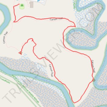
Carson Loop Trail
- Distance: 1.3 Km
- Elevation gain: 13 m
- Maximum elevation: 12 m
- Elevation loss: 9 m
- Minimum elevation: 4 m
- Moving time: 23 m 48 s
- Moving speed: 3.3 Km/h
- Maximum speed: 9.1 Km/h
- Total time: 34 m 11 s
- Global speed: 2.3 Km/h
Interactive trail map
Trail profile
- Distance: 1.3 Km
- Elevation gain: 13 m
- Maximum elevation: 12 m
- Elevation loss: 9 m
- Minimum elevation: 4 m
- Moving time: 23 m 48 s
- Moving speed: 3.3 Km/h
- Maximum speed: 9.1 Km/h
- Total time: 34 m 11 s
- Global speed: 2.3 Km/h
About this trail
Name: Carson Loop Trail trail, distance, elevation, map, profile, GPS track
Start: Carson Trail, Wells, York County, Maine, 04090, United States (43.34526 -70.54833)
End: Carson Trail, Wells, York County, Maine, 04090, United States (43.34708 -70.54839)
Coordinates: 43.34343 -70.54869 43.34708 -70.54464