Make a donation
Gear up for your next adventure:
As an Amazon Associate, this site earns from qualifying purchases at no extra cost to you.
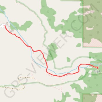
Dripping Springs Trail in Organ Mountain-Desert Peaks National Monument
The Dripping Springs Trail offers a delightful journey through stunning desert landscapes and fascinating historical remnants. Along the route, you'll be treated to breathtaking views of the jagged Organ Mountains and a variety of blooming wildflowers, especially in spring, adding vibrant colors to the scenery. The trail leads to the tranquil Dripping Springs, where you can enjoy a peaceful break surrounded by nature's beauty, making it a perfect escape for hikers of all levels. #Hiking #Mountain #River #Nature
- Distance: 4.6 Km
- Elevation gain: 153 m
- Maximum elevation: 1,877 m
- Elevation loss: 153 m
- Minimum elevation: 1,724 m
- Moving time: 1 h 18 m
- Moving speed: 3.5 Km/h
- Maximum speed: 5.1 Km/h
- Total time: 1 h 46 m
- Global speed: 2.6 Km/h
Interactive trail map
Make a donation
Gear up for your next adventure:
As an Amazon Associate, this site earns from qualifying purchases at no extra cost to you.
Trail profile
- Distance: 4.6 Km
- Elevation gain: 153 m
- Maximum elevation: 1,877 m
- Elevation loss: 153 m
- Minimum elevation: 1,724 m
- Moving time: 1 h 18 m
- Moving speed: 3.5 Km/h
- Maximum speed: 5.1 Km/h
- Total time: 1 h 46 m
- Global speed: 2.6 Km/h
Make a donation
Gear up for your next adventure:
As an Amazon Associate, this site earns from qualifying purchases at no extra cost to you.
About this trail
Name: Dripping Springs Trail in Organ Mountain-Desert Peaks National Monument trail, distance, elevation, map, profile, GPS track
Start: Dripping Springs Road, Doña Ana County, New Mexico, United States (32.32962 -106.59060)
End: Dripping Springs Trail, Boyd, Doña Ana County, New Mexico, United States (32.32958 -106.59062)
Coordinates: 32.32177 -106.59062 32.32962 -106.57336
Make a donation
Gear up for your next adventure:
As an Amazon Associate, this site earns from qualifying purchases at no extra cost to you.