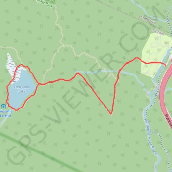
Lonesome Lake Loop Trail in Franconia Notch State Park
The Lonesome Lake Loop Trail offers hikers a scenic escape, winding through dense forests and eventually opening up to serene lake views framed by the rugged peaks of Franconia Ridge. As you hike around the lake, boardwalks cross wetland areas, and the calming sounds of nature create a peaceful ambiance, with Mount Lafayette and Mount Lincoln rising impressively in the distance. For those looking to extend their experience, the nearby AMC Lonesome Lake Hut provides rustic amenities and beautiful vantage points, making this trail a popular yet tranquil choice for nature lovers and photographers alike. #Hiking #Loop #Lake #Mountain #Forest #Nature
- Distance: 5.0 Km
- Elevation gain: 309 m
- Maximum elevation: 840 m
- Elevation loss: 309 m
- Minimum elevation: 536 m
- Moving time: 1 h 18 m
- Moving speed: 3.8 Km/h
- Maximum speed: 6.9 Km/h
- Total time: 1 h 31 m
- Global speed: 3.3 Km/h
Interactive trail map
Trail profile
- Distance: 5.0 Km
- Elevation gain: 309 m
- Maximum elevation: 840 m
- Elevation loss: 309 m
- Minimum elevation: 536 m
- Moving time: 1 h 18 m
- Moving speed: 3.8 Km/h
- Maximum speed: 6.9 Km/h
- Total time: 1 h 31 m
- Global speed: 3.3 Km/h
About this trail
Name: Lonesome Lake Loop Trail in Franconia Notch State Park trail, distance, elevation, map, profile, GPS track
Coordinates: 44.13766 -71.70281 44.14249 -71.68394
Other hiking, mountain biking, running and outdoor activity trails
Click on a trail to view its statistics, map and profile.
Lonesome Lake Loop Trail in Franconia Notch State Park
United States > New Hampshire > Grafton County > Lincoln
The Lonesome Lake Loop Trail in Franconia Notch State Park offers hikers a moderately challenging journey through diverse terrains. Starting from the Lafayette Place Campground, the trail ascends through a forested path, leading to the serene Lonesome Lake nestled amidst the towering peaks of Cannon Mountain,…
Distance: 5.1 Km • Elevation gain: 309 m • Maximum elevation: 840 m