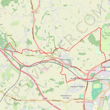
Trailrun Warwick-Shrewley
- Distance: 22.9 Km
- Elevation gain: 184 m
- Maximum elevation: 126 m
- Elevation loss: 185 m
- Minimum elevation: 57 m
- Moving time: 2 h 11 m
- Moving speed: 10.5 Km/h
- Maximum speed: 16.1 Km/h
- Total time: 2 h 12 m
- Global speed: 10.4 Km/h
Interactive trail map
Trail profile
- Distance: 22.9 Km
- Elevation gain: 184 m
- Maximum elevation: 126 m
- Elevation loss: 185 m
- Minimum elevation: 57 m
- Moving time: 2 h 11 m
- Moving speed: 10.5 Km/h
- Maximum speed: 16.1 Km/h
- Total time: 2 h 12 m
- Global speed: 10.4 Km/h
About this trail
Name: Trailrun Warwick-Shrewley trail, distance, elevation, map, profile, GPS track
Coordinates: 52.28496 -1.69660 52.32012 -1.59090
Other hiking, mountain biking, running and outdoor activity trails
Click on a trail to view its statistics, map and profile.
Henley-in-Arden to Shrewley trailrun
United Kingdom > England > Warwickshire > Stratford-on-Avon > Henley-in-Arden
Distance: 19.6 Km • Elevation gain: 284 m • Maximum elevation: 124 m