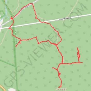
Tracks of trails on Tranquility Ridge in Ringwood, NJ
- Distance: 6.8 Km
- Elevation gain: 260 m
- Maximum elevation: 282 m
- Elevation loss: 258 m
- Minimum elevation: 130 m
- Moving time: 2 h 34 m
- Moving speed: 2.7 Km/h
- Maximum speed: 4.5 Km/h
- Total time: 3 h 29 m
- Global speed: 2.0 Km/h
Interactive trail map
Trail profile
- Distance: 6.8 Km
- Elevation gain: 260 m
- Maximum elevation: 282 m
- Elevation loss: 258 m
- Minimum elevation: 130 m
- Moving time: 2 h 34 m
- Moving speed: 2.7 Km/h
- Maximum speed: 4.5 Km/h
- Total time: 3 h 29 m
- Global speed: 2.0 Km/h
About this trail
Name: Tracks of trails on Tranquility Ridge in Ringwood, NJ trail, distance, elevation, map, profile, GPS track
End: Beech Road, Ringwood, Passaic County, New Jersey, 10979, United States (41.14502 -74.29737)
Coordinates: 41.13536 -74.29787 41.14726 -74.28400