Turkey Mountain Ten Four MTB Trail
- Distance: 0.8 Km
- Elevation gain: 2 m
- Maximum elevation: 261 m
- Elevation loss: 17 m
- Minimum elevation: 243 m
- Moving time: 9 m 25 s
- Moving speed: 5.2 Km/h
- Maximum speed: 8.1 Km/h
- Total time: 14 m 39 s
- Global speed: 3.3 Km/h
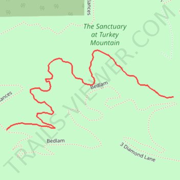
Interactive trail map
Trail profile
- Distance: 0.8 Km
- Elevation gain: 2 m
- Maximum elevation: 261 m
- Elevation loss: 17 m
- Minimum elevation: 243 m
- Moving time: 9 m 25 s
- Moving speed: 5.2 Km/h
- Maximum speed: 8.1 Km/h
- Total time: 14 m 39 s
- Global speed: 3.3 Km/h
About this trail
Name: Turkey Mountain Ten Four MTB Trail trail, distance, elevation, map, profile, GPS track
Start: Bedlam, Tulsa, Tulsa County, Oklahoma, 74132, United States (36.07023 -95.99824)
End: Checks and Balances, Tulsa, Tulsa County, Oklahoma, 74132, United States (36.06961 -96.00214)
Coordinates: 36.06961 -96.00214 36.07112 -95.99824
Other hiking, mountain biking, running and outdoor activity trails
Click on a trail to view its statistics, map and profile.
Turkey Mountain Checks and Balances MTB Trail
United States > Oklahoma > Tulsa County > Tulsa
Distance: 2.2 Km • Elevation gain: 34 m • Maximum elevation: 262 m