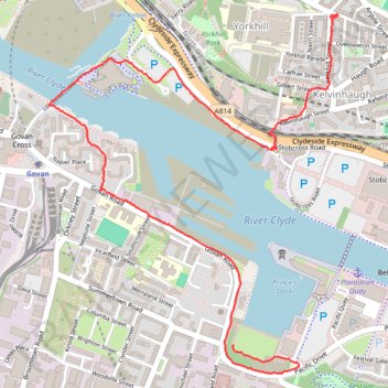
Govan-Partick Bridge
- Distance: 3.8 Km
- Elevation gain: 37 m
- Maximum elevation: 27 m
- Elevation loss: 16 m
- Minimum elevation: 2 m
- Moving time: 45 m 47 s
- Moving speed: 5.0 Km/h
- Maximum speed: 8.9 Km/h
- Total time: 45 m 47 s
- Global speed: 5.0 Km/h
Interactive trail map
Trail profile
- Distance: 3.8 Km
- Elevation gain: 37 m
- Maximum elevation: 27 m
- Elevation loss: 16 m
- Minimum elevation: 2 m
- Moving time: 45 m 47 s
- Moving speed: 5.0 Km/h
- Maximum speed: 8.9 Km/h
- Total time: 45 m 47 s
- Global speed: 5.0 Km/h
About this trail
Name: Govan-Partick Bridge trail, distance, elevation, map, profile, GPS track
Coordinates: 55.85528 -4.30989 55.86724 -4.29274
Other hiking, mountain biking, running and outdoor activity trails
Click on a trail to view its statistics, map and profile.
Johnstone, Scotland to Paisley via Glasgow
United Kingdom > Scotland > Renfrewshire > Johnstone
Bike
Distance: 65.2 Km • Elevation gain: 458 m • Maximum elevation: 53 m
Critical Mass Glasgow
United Kingdom > Scotland > Glasgow City > Glasgow
Bike
Distance: 20.0 Km • Elevation gain: 150 m • Maximum elevation: 37 m