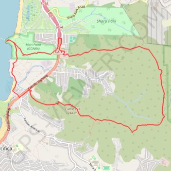
Vallemar Loop
Loop hike around Vallemar via Mori Ridge Trail, Sweeney Ridge Trail, Baquiano Trail, Castle Hill, Farallones View Trail, Rockaway Beach, Bluff Trail, Headlands Trail, The Point and Timigtac Trail in the San Francisco Peninsula Watershed, the Mori Point and the Golden Gate National Recreation Area (GGNRA). #Hiking #Loop #Nature #Mountain #Sea #Pacific #Ocean #Coast #Overlook #Beach #GGNRA
- Distance: 12.1 Km
- Elevation gain: 560 m
- Maximum elevation: 375 m
- Elevation loss: 562 m
- Minimum elevation: 0 m
- Moving time: 2 h 28 m
- Moving speed: 4.9 Km/h
- Maximum speed: 6.5 Km/h
- Total time: 2 h 29 m
- Global speed: 4.8 Km/h
Interactive trail map
Trail profile
- Distance: 12.1 Km
- Elevation gain: 560 m
- Maximum elevation: 375 m
- Elevation loss: 562 m
- Minimum elevation: 0 m
- Moving time: 2 h 28 m
- Moving speed: 4.9 Km/h
- Maximum speed: 6.5 Km/h
- Total time: 2 h 29 m
- Global speed: 4.8 Km/h
About this trail
Name: Vallemar Loop trail, distance, elevation, map, profile, GPS track
Coordinates: 37.60126 -122.49871 37.62062 -122.45782