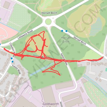
Horsell Birch paths
Woking, horsell, horsell common, horsell birch
- Distance: 3.5 Km
- Elevation gain: 6 m
- Maximum elevation: 28 m
- Elevation loss: 6 m
- Minimum elevation: 24 m
- Moving time: 45 m 6 s
- Moving speed: 4.6 Km/h
- Maximum speed: 16.9 Km/h
- Total time: 46 m 23 s
- Global speed: 4.5 Km/h
Interactive trail map
Trail profile
- Distance: 3.5 Km
- Elevation gain: 6 m
- Maximum elevation: 28 m
- Elevation loss: 6 m
- Minimum elevation: 24 m
- Moving time: 45 m 6 s
- Moving speed: 4.6 Km/h
- Maximum speed: 16.9 Km/h
- Total time: 46 m 23 s
- Global speed: 4.5 Km/h
About this trail
Name: Horsell Birch paths trail, distance, elevation, map, profile, GPS track
Start: Horsell Birch, Horsell, Woking, Surrey, England, GU21 4XB, United Kingdom (51.32663 -0.58195)
End: Horsell Birch, Horsell, Woking, Surrey, England, GU21 4XB, United Kingdom (51.32661 -0.58194)
Coordinates: 51.32568 -0.58994 51.32792 -0.58194