Import a GPX file

New path around Birchall playing fields

  • Distance: 1.7 Km
  • Elevation gain: 15 m
  • Maximum elevation: 157 m
  • Elevation loss: 16 m
  • Minimum elevation: 144 m
  • Moving time: 24 m 57 s
  • Moving speed: 4.2 Km/h
  • Maximum speed: 6.1 Km/h
  • Total time: 25 m 25 s
  • Global speed: 4.1 Km/h

Interactive trail map

Trail profile

  • Distance: 1.7 Km
  • Elevation gain: 15 m
  • Maximum elevation: 157 m
  • Elevation loss: 16 m
  • Minimum elevation: 144 m
  • Moving time: 24 m 57 s
  • Moving speed: 4.2 Km/h
  • Maximum speed: 6.1 Km/h
  • Total time: 25 m 25 s
  • Global speed: 4.1 Km/h

About this trail

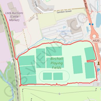
Name: New path around Birchall playing fields trail, distance, elevation, map, profile, GPS track

Start: Junction Road, Leek, Staffordshire Moorlands, Staffordshire, England, ST13 5QP, United Kingdom (53.09632 -2.03011)

End: Barnfield Road, Leek, Staffordshire Moorlands, Staffordshire, England, ST13 5QJ, United Kingdom (53.09399 -2.02902)

Coordinates: 53.09261 -2.03011 53.09632 -2.02206

Gear up for your next adventure:

🕯️Emergency Whistles - Safety whistles for hiking
🎒Hiking Backpacks - Backpacks designed for hiking and trekking
🎒Dry Bags - Waterproof bags for outdoor gear
🦟Heavy Duty Insect Repellent - Essential protection against flies, mozzies, and march flies
🍶Collapsible Water Bottles - Save space in your pack as you consume your water supply

As an Amazon Associate, this site earns from qualifying purchases at no extra cost to you.