Thank you for supporting this site ❤️
Make a donation
Make a donation
Gear up for your next adventure:
As an Amazon Associate, this site earns from qualifying purchases at no extra cost to you.
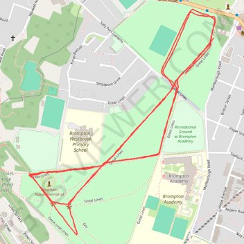
Great Lines Parkrun
- Distance: 5.0 Km
- Elevation gain: 51 m
- Maximum elevation: 60 m
- Elevation loss: 54 m
- Minimum elevation: 38 m
- Moving time: 29 m 52 s
- Moving speed: 10.1 Km/h
- Maximum speed: 14.4 Km/h
- Total time: 29 m 52 s
- Global speed: 10.1 Km/h
Interactive trail map
Thank you for supporting this site ❤️
Make a donation
Make a donation
Gear up for your next adventure:
As an Amazon Associate, this site earns from qualifying purchases at no extra cost to you.
Trail profile
- Distance: 5.0 Km
- Elevation gain: 51 m
- Maximum elevation: 60 m
- Elevation loss: 54 m
- Minimum elevation: 38 m
- Moving time: 29 m 52 s
- Moving speed: 10.1 Km/h
- Maximum speed: 14.4 Km/h
- Total time: 29 m 52 s
- Global speed: 10.1 Km/h
Thank you for supporting this site ❤️
Make a donation
Make a donation
Gear up for your next adventure:
As an Amazon Associate, this site earns from qualifying purchases at no extra cost to you.
About this trail
Name: Great Lines Parkrun trail, distance, elevation, map, profile, GPS track
Start: Great Lines, Brompton, Gillingham, Medway, England, ME7 5DH, United Kingdom (51.38735 0.53965)
End: Great Lines, Brompton, Gillingham, Medway, England, ME7 5BZ, United Kingdom (51.38857 0.54122)
Coordinates: 51.38181 0.53104 51.38957 0.54130
Thank you for supporting this site ❤️
Make a donation
Make a donation
Gear up for your next adventure:
As an Amazon Associate, this site earns from qualifying purchases at no extra cost to you.