Thank you for supporting this site ❤️
Make a donation
Make a donation
Gear up for your next adventure:
As an Amazon Associate, this site earns from qualifying purchases at no extra cost to you.
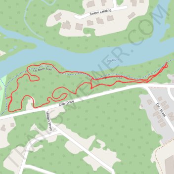
Salamander Ridge Loop Trail
- Distance: 2.4 Km
- Elevation gain: 7 m
- Maximum elevation: 34 m
- Elevation loss: 8 m
- Minimum elevation: 28 m
- Moving time: 32 m 23 s
- Moving speed: 4.5 Km/h
- Maximum speed: 6.6 Km/h
- Total time: 32 m 23 s
- Global speed: 4.5 Km/h
Interactive trail map
Thank you for supporting this site ❤️
Make a donation
Make a donation
Gear up for your next adventure:
As an Amazon Associate, this site earns from qualifying purchases at no extra cost to you.
Trail profile
- Distance: 2.4 Km
- Elevation gain: 7 m
- Maximum elevation: 34 m
- Elevation loss: 8 m
- Minimum elevation: 28 m
- Moving time: 32 m 23 s
- Moving speed: 4.5 Km/h
- Maximum speed: 6.6 Km/h
- Total time: 32 m 23 s
- Global speed: 4.5 Km/h
Thank you for supporting this site ❤️
Make a donation
Make a donation
Gear up for your next adventure:
As an Amazon Associate, this site earns from qualifying purchases at no extra cost to you.
About this trail
Name: Salamander Ridge Loop Trail trail, distance, elevation, map, profile, GPS track
Coordinates: 35.95555 -77.81293 35.95710 -77.80671
Thank you for supporting this site ❤️
Make a donation
Make a donation
Gear up for your next adventure:
As an Amazon Associate, this site earns from qualifying purchases at no extra cost to you.