Thank you for supporting this site ❤️
Make a donation
Make a donation
Gear up for your next adventure:
As an Amazon Associate, this site earns from qualifying purchases at no extra cost to you.
Noble Canyon
Interactive trail map
Thank you for supporting this site ❤️
Make a donation
Make a donation
Gear up for your next adventure:
As an Amazon Associate, this site earns from qualifying purchases at no extra cost to you.
Trail profile
- Distance: 4.3 Km
- Elevation gain: 126 m
- Maximum elevation: 1,285 m
- Elevation loss: 161 m
- Minimum elevation: 1,130 m
Thank you for supporting this site ❤️
Make a donation
Make a donation
Gear up for your next adventure:
🧭Military Style Lensatic Compass - Durable sighting compasses for advanced land navigation and surveying
🧭Global Orienteering Compass - High-precision liquid-filled compasses for accurate map reading and navigation
As an Amazon Associate, this site earns from qualifying purchases at no extra cost to you.
About this trail
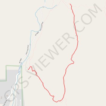
Name: Noble Canyon trail, distance, elevation, map, profile, GPS track
Start: Noble Canyon Trail, San Diego County, California, 91962, United States (32.86472 -116.51142)
End: Noble Canyon Trail, San Diego County, California, 91962, United States (32.84975 -116.52278)
Coordinates: 32.84230 -116.52278 32.86472 -116.50923
Thank you for supporting this site ❤️
Make a donation
Make a donation
Gear up for your next adventure:
As an Amazon Associate, this site earns from qualifying purchases at no extra cost to you.