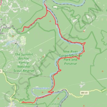
New River Gorge National Park and Preserve
- Distance: 33.2 Km
- Elevation gain: 1,090 m
- Maximum elevation: 547 m
- Elevation loss: 986 m
- Minimum elevation: 314 m
- Moving time: 2 h 8 m
- Moving speed: 15.5 Km/h
- Maximum speed: 68.3 Km/h
- Total time: 2 h 59 m
- Global speed: 11.1 Km/h
Interactive trail map
Trail profile
- Distance: 33.2 Km
- Elevation gain: 1,090 m
- Maximum elevation: 547 m
- Elevation loss: 986 m
- Minimum elevation: 314 m
- Moving time: 2 h 8 m
- Moving speed: 15.5 Km/h
- Maximum speed: 68.3 Km/h
- Total time: 2 h 59 m
- Global speed: 11.1 Km/h
About this trail
Name: New River Gorge National Park and Preserve trail, distance, elevation, map, profile, GPS track
Start: Thurmond Road, Fayette County, West Virginia, 25846, United States (37.92764 -81.11616)
End: Johnstown Road, Piney View, Raleigh County, West Virginia, 25906, United States (37.84339 -81.11611)
Coordinates: 37.84270 -81.11616 37.96078 -81.02005
Other hiking, mountain biking, running and outdoor activity trails
Click on a trail to view its statistics, map and profile.
Turkey Spur Rock via Grandview Rim Trail in New River Gorge National Park and Preserve
United States > West Virginia > Raleigh County > Grandview
The Grandview Rim Trail leading to Turkey Spur Rock offers a truly rewarding hike in New River Gorge National Park. Starting at the Main Overlook, the trail winds through lush forests and along the rim of the gorge, providing frequent stops to admire breathtaking views of the deep river valley below. The…
Distance: 5.5 Km • Elevation gain: 150 m • Maximum elevation: 762 m
New River Gorge
United States > West Virginia > Mercer County > Athens
Distance: 206.3 Km • Elevation gain: 5,337 m • Maximum elevation: 851 m