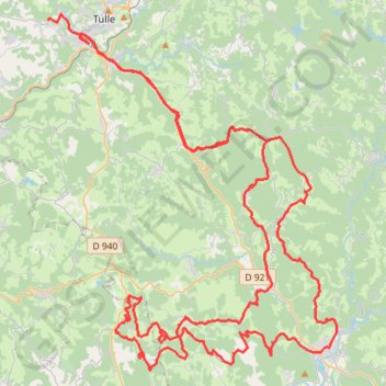
2021-02-20-01
- Distance: 119.9 Km
- Elevation gain: 2,982 m
- Maximum elevation: 627 m
- Elevation loss: 3,154 m
- Minimum elevation: 181 m
Interactive trail map
Trail profile
- Distance: 119.9 Km
- Elevation gain: 2,982 m
- Maximum elevation: 627 m
- Elevation loss: 3,154 m
- Minimum elevation: 181 m
About this trail
Name: 2021-02-20-01 trail, distance, elevation, map, profile, GPS track
Coordinates: 45.08296 1.72953 45.27006 1.94380
Other hiking, mountain biking, running and outdoor activity trails
Click on a trail to view its statistics, map and profile.
Chemin de Saint-Jacques-de-Compostelle
Switzerland > Geneva > Geneva
Distance: 1,117.8 Km • Elevation gain: 25,262 m • Maximum elevation: 1,430 m
GR 654 - Le chemin vers Saint-Jacques-de-Compostelle via Vézelay
France > Nouvelle-Aquitaine > Dordogne > Bergerac
Distance: 810.9 Km • Elevation gain: 9,631 m • Maximum elevation: 670 m