Thank you for supporting this site ❤️
Make a donation
Make a donation
Gear up for your next adventure:
As an Amazon Associate, this site earns from qualifying purchases at no extra cost to you.
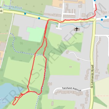
Clayton hill lake paths
- Distance: 1.4 Km
- Elevation gain: 12 m
- Maximum elevation: 32 m
- Elevation loss: 9 m
- Minimum elevation: 25 m
- Moving time: 20 m 30 s
- Moving speed: 4.2 Km/h
- Maximum speed: 6.6 Km/h
- Total time: 23 m 28 s
- Global speed: 3.7 Km/h
Interactive trail map
Thank you for supporting this site ❤️
Make a donation
Make a donation
Gear up for your next adventure:
As an Amazon Associate, this site earns from qualifying purchases at no extra cost to you.
Trail profile
- Distance: 1.4 Km
- Elevation gain: 12 m
- Maximum elevation: 32 m
- Elevation loss: 9 m
- Minimum elevation: 25 m
- Moving time: 20 m 30 s
- Moving speed: 4.2 Km/h
- Maximum speed: 6.6 Km/h
- Total time: 23 m 28 s
- Global speed: 3.7 Km/h
Thank you for supporting this site ❤️
Make a donation
Make a donation
Gear up for your next adventure:
As an Amazon Associate, this site earns from qualifying purchases at no extra cost to you.
About this trail
Name: Clayton hill lake paths trail, distance, elevation, map, profile, GPS track
Coordinates: 51.73149 0.00659 51.73619 0.01289
Thank you for supporting this site ❤️
Make a donation
Make a donation
Gear up for your next adventure:
As an Amazon Associate, this site earns from qualifying purchases at no extra cost to you.