Thank you for supporting this site ❤️
Make a donation
Make a donation
Gear up for your next adventure:
As an Amazon Associate, this site earns from qualifying purchases at no extra cost to you.
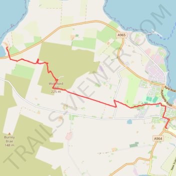
Orkney Mainland Hike via Wideford Hill
- Distance: 7.9 Km
- Elevation gain: 235 m
- Maximum elevation: 225 m
- Elevation loss: 242 m
- Minimum elevation: 3 m
- Moving time: 1 h 51 m
- Moving speed: 4.3 Km/h
- Maximum speed: 6.8 Km/h
- Total time: 2 h 4 m
- Global speed: 3.8 Km/h
Interactive trail map
Thank you for supporting this site ❤️
Make a donation
Make a donation
Gear up for your next adventure:
As an Amazon Associate, this site earns from qualifying purchases at no extra cost to you.
Trail profile
- Distance: 7.9 Km
- Elevation gain: 235 m
- Maximum elevation: 225 m
- Elevation loss: 242 m
- Minimum elevation: 3 m
- Moving time: 1 h 51 m
- Moving speed: 4.3 Km/h
- Maximum speed: 6.8 Km/h
- Total time: 2 h 4 m
- Global speed: 3.8 Km/h
Thank you for supporting this site ❤️
Make a donation
Make a donation
Gear up for your next adventure:
As an Amazon Associate, this site earns from qualifying purchases at no extra cost to you.
About this trail
Name: Orkney Mainland Hike via Wideford Hill trail, distance, elevation, map, profile, GPS track
End: A965, Kirkwall, Orkney Islands, Scotland, KW15 1TY, United Kingdom (58.99392 -3.04968)
Coordinates: 58.97476 -3.05103 58.99618 -2.96792
Thank you for supporting this site ❤️
Make a donation
Make a donation
Gear up for your next adventure:
As an Amazon Associate, this site earns from qualifying purchases at no extra cost to you.