Import a GPX file

Palomar Observatory

Hike on the Observatory Trail to the Palomar Observatory in the Cleveland National Forest. #Hiking #Mountain #Forest #Nature

  • Distance: 3.9 Km
  • Elevation gain: 239 m
  • Maximum elevation: 1,699 m
  • Elevation loss: 21 m
  • Minimum elevation: 1,481 m

Interactive trail map

Trail profile

  • Distance: 3.9 Km
  • Elevation gain: 239 m
  • Maximum elevation: 1,699 m
  • Elevation loss: 21 m
  • Minimum elevation: 1,481 m

About this trail

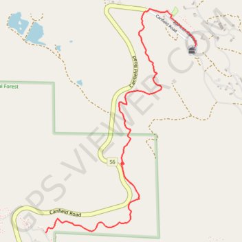
Name: Palomar Observatory trail, distance, elevation, map, profile, GPS track

Start: Observatory Campground, San Diego County, California, 92060, United States (33.34312 -116.87745)

End: 200-inch Catwalk, San Diego County, California, 92060, United States (33.35653 -116.86456)

Coordinates: 33.34312 -116.87745 33.35919 -116.86452

Other hiking, mountain biking, running and outdoor activity trails

Click on a trail to view its statistics, map and profile.

Palomar trail, first part

United States > California > San Diego County

Distance: 2.1 Km • Elevation gain: 74 m • Maximum elevation: 1,527 m

Gear up for your next adventure:

👟Lightweight Trail Runners - Agile footwear for fast movement over rugged Australian terrain
🎨Portable Watercolor Kits - Paint the landscapes and topographic views you discover
📦Crushproof Equipment Cases - Safe transport for sensitive surveying and mapping instruments
🖼️Scratch-off Australia Map - Track the regions and peaks you have explored geographically
🔦Powerful LED Headlamps - Hands-free lighting for night navigation and setting up camp after dark

As an Amazon Associate, this site earns from qualifying purchases at no extra cost to you.