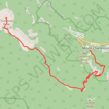
Charleston Peak
Hike to Charleston Peak from Mount Charleston via South Loop Trail. #Hiking #Mountain #Nature #Forest #Wilderness
- Distance: 13.2 Km
- Elevation gain: 1,472 m
- Maximum elevation: 3,629 m
- Elevation loss: 190 m
- Minimum elevation: 2,338 m
- Moving time: 1 h 17 m
- Moving speed: 10.2 Km/h
- Maximum speed: 12.5 Km/h
- Total time: 1 h 17 m
- Global speed: 10.2 Km/h
Interactive trail map
Trail profile
- Distance: 13.2 Km
- Elevation gain: 1,472 m
- Maximum elevation: 3,629 m
- Elevation loss: 190 m
- Minimum elevation: 2,338 m
- Moving time: 1 h 17 m
- Moving speed: 10.2 Km/h
- Maximum speed: 12.5 Km/h
- Total time: 1 h 17 m
- Global speed: 10.2 Km/h
About this trail
Name: Charleston Peak trail, distance, elevation, map, profile, GPS track
Start: Cathedral Rock Trail, Mount Charleston, Clark County, Nevada, United States (36.25614 -115.64546)
Coordinates: 36.23642 -115.69690 36.27176 -115.63717