Thank you for supporting this site ❤️
Make a donation
Make a donation
Gear up for your next adventure:
As an Amazon Associate, this site earns from qualifying purchases at no extra cost to you.
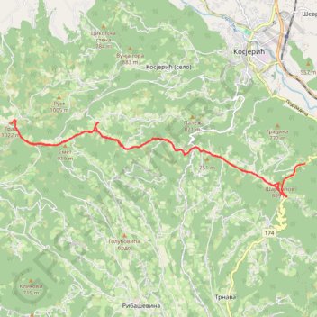
Trenutna trasa: 12 SIJ 2020 08:22
- Distance: 18.6 Km
- Elevation gain: 637 m
- Maximum elevation: 1,013 m
- Elevation loss: 573 m
- Minimum elevation: 704 m
- Moving time: 4 h 39 m
- Moving speed: 4.0 Km/h
- Maximum speed: 38.5 Km/h
- Total time: 5 h 19 m
- Global speed: 3.5 Km/h
Interactive trail map
Thank you for supporting this site ❤️
Make a donation
Make a donation
Gear up for your next adventure:
As an Amazon Associate, this site earns from qualifying purchases at no extra cost to you.
Trail profile
- Distance: 18.6 Km
- Elevation gain: 637 m
- Maximum elevation: 1,013 m
- Elevation loss: 573 m
- Minimum elevation: 704 m
- Moving time: 4 h 39 m
- Moving speed: 4.0 Km/h
- Maximum speed: 38.5 Km/h
- Total time: 5 h 19 m
- Global speed: 3.5 Km/h
Thank you for supporting this site ❤️
Make a donation
Make a donation
Gear up for your next adventure:
As an Amazon Associate, this site earns from qualifying purchases at no extra cost to you.
About this trail
Name: Trenutna trasa: 12 SIJ 2020 08:22 trail, distance, elevation, map, profile, GPS track
Coordinates: 43.96427 19.83318 43.98140 19.92471
Thank you for supporting this site ❤️
Make a donation
Make a donation
Gear up for your next adventure:
As an Amazon Associate, this site earns from qualifying purchases at no extra cost to you.
Other hiking, mountain biking, running and outdoor activity trails
Click on a trail to view its statistics, map and profile.
2022_Yu
Slovenia > Ajdovščina > Žapuže
Distance: 2,457.3 Km • Elevation gain: 32,048 m • Maximum elevation: 1,950 m