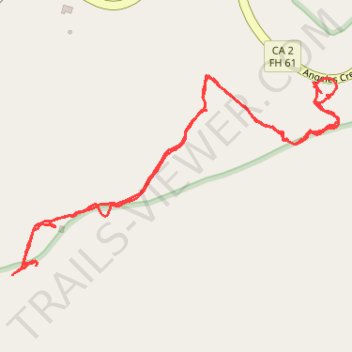
Kratka Ridge hike from east
- Distance: 2.6 Km
- Elevation gain: 200 m
- Maximum elevation: 2,277 m
- Elevation loss: 201 m
- Minimum elevation: 2,085 m
- Moving time: 1 h 14 m
- Moving speed: 2.1 Km/h
- Maximum speed: 4.9 Km/h
- Total time: 2 h 8 m
- Global speed: 1.2 Km/h
Interactive trail map
Trail profile
- Distance: 2.6 Km
- Elevation gain: 200 m
- Maximum elevation: 2,277 m
- Elevation loss: 201 m
- Minimum elevation: 2,085 m
- Moving time: 1 h 14 m
- Moving speed: 2.1 Km/h
- Maximum speed: 4.9 Km/h
- Total time: 2 h 8 m
- Global speed: 1.2 Km/h
About this trail
Name: Kratka Ridge hike from east trail, distance, elevation, map, profile, GPS track
Coordinates: 34.34646 -117.89970 34.35024 -117.89226
Other hiking, mountain biking, running and outdoor activity trails
Click on a trail to view its statistics, map and profile.
Goodykoontz Peak via Burkhardt Trail and x-country from Buckhorn CG
United States > California > Los Angeles County
Distance: 10.9 Km • Elevation gain: 855 m • Maximum elevation: 2,298 m