Thank you for supporting this site ❤️
Make a donation
Make a donation
Gear up for your next adventure:
🧊Insulated Stainless Steel Flasks - Keep water cold for 24 hours in the heat or coffee hot in the cold
As an Amazon Associate, this site earns from qualifying purchases at no extra cost to you.
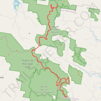
Gidjuum Gulganyi Complete
- Distance: 42.2 Km
- Elevation gain: 1,878 m
- Maximum elevation: 821 m
- Elevation loss: 1,746 m
- Minimum elevation: 112 m
- Moving time: 8 h 27 m
- Moving speed: 5.0 Km/h
- Maximum speed: 5.9 Km/h
- Total time: 8 h 27 m
- Global speed: 5.0 Km/h
Interactive trail map
Thank you for supporting this site ❤️
Make a donation
Make a donation
Gear up for your next adventure:
As an Amazon Associate, this site earns from qualifying purchases at no extra cost to you.
Trail profile
- Distance: 42.2 Km
- Elevation gain: 1,878 m
- Maximum elevation: 821 m
- Elevation loss: 1,746 m
- Minimum elevation: 112 m
- Moving time: 8 h 27 m
- Moving speed: 5.0 Km/h
- Maximum speed: 5.9 Km/h
- Total time: 8 h 27 m
- Global speed: 5.0 Km/h
Thank you for supporting this site ❤️
Make a donation
Make a donation
Gear up for your next adventure:
As an Amazon Associate, this site earns from qualifying purchases at no extra cost to you.
About this trail
Name: Gidjuum Gulganyi Complete trail, distance, elevation, map, profile, GPS track
End: Minyon Falls Loop Road, Byron Shire Council, New South Wales, Australia (-28.61158 153.39049)
Coordinates: -28.61259 153.32858 -28.46612 153.39548
Topography: New South Wales topographic map, elevation, terrain
Thank you for supporting this site ❤️
Make a donation
Make a donation
Gear up for your next adventure:
As an Amazon Associate, this site earns from qualifying purchases at no extra cost to you.
Other hiking, mountain biking, running and outdoor activity trails
Click on a trail to view its statistics, map and profile.