
Munro Hillwalk - Ring of Steall
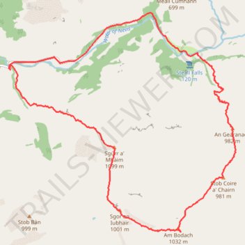
Starting at Glen Nevis Lower Falls, this anticlockwise Ring of Steall climb rises from the Water of Nevis onto the pale quartzite slopes of Sgùrr a’ Mhàim, where the view opens across Glen Nevis, Ben Nevis and the Mamores.
The route then follows the high ridge over The Devil’s Ridge and Sgòr an Iubhair toward Am Bodach, continuing across the rugged crest to Stob Coire a’ Chàirn and An Gearanach, a classic sequence of Munro summits, narrow arêtes and rocky Highland terrain.
From An Gearanach, the descent returns toward the Steall side of the glen, meeting the Water of Nevis and its gorge scenery before the final walk out along Glen Nevis Road.
#Hiking #Loop #Mountain #Hill #Nature #River
- Distance: 18.7 Km
- Elevation gain: 1,646 m
- Maximum elevation: 1,089 m
- Elevation loss: 1,646 m
- Minimum elevation: 56 m
- Moving time: 7 h 18 m
- Moving speed: 2.6 Km/h
- Maximum speed: 31.4 Km/h
- Total time: 9 h 17 m
- Global speed: 2.0 Km/h
Interactive trail map
Trail profile
- Distance: 18.7 Km
- Elevation gain: 1,646 m
- Maximum elevation: 1,089 m
- Elevation loss: 1,646 m
- Minimum elevation: 56 m
- Moving time: 7 h 18 m
- Moving speed: 2.6 Km/h
- Maximum speed: 31.4 Km/h
- Total time: 9 h 17 m
- Global speed: 2.0 Km/h
About this trail
Name: Munro Hillwalk - Ring of Steall trail, distance, elevation, map, profile, GPS track
Start: Glen Nevis Road, Achriabhach, Highland, Scotland, PH33 6FT, United Kingdom (56.76941 -5.03642)
End: Glen Nevis Road, Achriabhach, Highland, Scotland, PH33 6FT, United Kingdom (56.76940 -5.03658)
Coordinates: 56.74120 -5.03690 56.77929 -4.96513
Other hiking, mountain biking, running and outdoor activity trails
Click on a trail to view its statistics, map and profile.
Munro, hillwalk, Choinnich, Mor, Aonach, Beag
United Kingdom > Scotland > Highland
Distance: 21.8 Km • Elevation gain: 1,736 m • Maximum elevation: 1,233 m