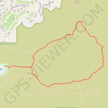
Import a GPX file

Gateway Loop

Scottsdale McDowell Sonoran Preserve. #Hiking #Running #MTB #Loop #Nature

  • Distance: 7.1 Km
  • Elevation gain: 231 m
  • Maximum elevation: 728 m
  • Elevation loss: 231 m
  • Minimum elevation: 523 m

Interactive trail map

Trail profile

  • Distance: 7.1 Km
  • Elevation gain: 231 m
  • Maximum elevation: 728 m
  • Elevation loss: 231 m
  • Minimum elevation: 523 m

About this trail

Other hiking, mountain biking, running and outdoor activity trails

Click on a trail to view its statistics, map and profile.

McDowell Sonoran Preserve

United States > Arizona > Maricopa County > Scottsdale

Loop through McDowell Sonoran Preserve hike from Gateway Trailhead via Gateway Loop Trail. #Hiking #Loop #Nature #Mountain #Desert

Distance: 6.2 Km • Elevation gain: 231 m • Maximum elevation: 728 m

Gear up for your next adventure:

📡Weather Radios - Emergency weather radios
📸Action Cameras - Record your journey across interesting topographic features in 4K
🥤Hydration Packs - Hydration systems for hiking
Survival Blankets - Emergency thermal blankets
🔥Camping Stoves - Portable stoves for outdoor cooking

As an Amazon Associate, this site earns from qualifying purchases at no extra cost to you.