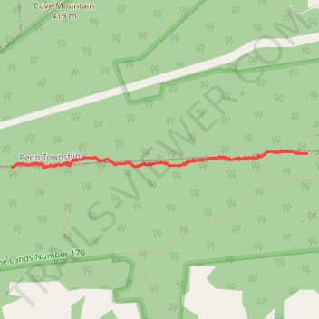
Teal-Blazed Trail SGL 170
- Distance: 5.4 Km
- Elevation gain: 80 m
- Maximum elevation: 372 m
- Elevation loss: 78 m
- Minimum elevation: 341 m
- Moving time: 1 h 5 m
- Moving speed: 5.0 Km/h
- Maximum speed: 11.0 Km/h
- Total time: 1 h 7 m
- Global speed: 4.9 Km/h
Interactive trail map
Trail profile
- Distance: 5.4 Km
- Elevation gain: 80 m
- Maximum elevation: 372 m
- Elevation loss: 78 m
- Minimum elevation: 341 m
- Moving time: 1 h 5 m
- Moving speed: 5.0 Km/h
- Maximum speed: 11.0 Km/h
- Total time: 1 h 7 m
- Global speed: 4.9 Km/h
About this trail
Name: Teal-Blazed Trail SGL 170 trail, distance, elevation, map, profile, GPS track
Start: Teal-Blazed Trail, Rye Township, Perry County, Pennsylvania, United States (40.34052 -77.06587)
End: Teal-Blazed Trail, Rye Township, Perry County, Pennsylvania, United States (40.34053 -77.06529)
Coordinates: 40.33941 -77.09492 40.34074 -77.06529