Solstice Canyon Loop
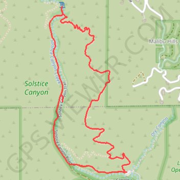
Interactive trail map
Trail profile
- Distance: 4.8 Km
- Elevation gain: 222 m
- Maximum elevation: 228 m
- Elevation loss: 222 m
- Minimum elevation: 42 m
About this trail
Name: Solstice Canyon Loop trail, distance, elevation, map, profile, GPS track
Start: TRW Loop Trail, Malibu, Los Angeles County, California, 90265, United States (34.03780 -118.74750)
End: TRW Loop Trail, Malibu, Los Angeles County, California, 90265, United States (34.03780 -118.74750)
Coordinates: 34.03772 -118.75440 34.05004 -118.74721
Other hiking, mountain biking, running and outdoor activity trails
Click on a trail to view its statistics, map and profile.
Solstice Canyon Loop
United States > California > Los Angeles County > Malibu
The Solstice Canyon Loop begins near the canyon entrance and climbs onto the sun-exposed Rising Sun Trail, where chaparral, coastal sage scrub, and open hillsides quickly replace the shaded canyon floor, revealing widening views across the folds of the Santa Monica Mountains and toward the Malibu coast. As the…
Distance: 4.8 Km • Elevation gain: 245 m • Maximum elevation: 228 m