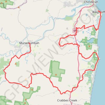
Murwillumbah - Kingscliff
#Bike
- Distance: 92.8 Km
- Elevation gain: 1,284 m
- Maximum elevation: 152 m
- Elevation loss: 1,284 m
- Minimum elevation: 1 m
Interactive trail map
Trail profile
- Distance: 92.8 Km
- Elevation gain: 1,284 m
- Maximum elevation: 152 m
- Elevation loss: 1,284 m
- Minimum elevation: 1 m
About this trail
Name: Murwillumbah - Kingscliff trail, distance, elevation, map, profile, GPS track
Start: 32;34;42, Murwillumbah, Tweed Shire Council, New South Wales, 2484, Australia (-28.32765 153.39575)
Coordinates: -28.44309 153.33214 -28.25432 153.58215
Topography: New South Wales topographic map, elevation, terrain