Import a GPX file

East Coast Trail - Beaches Path

#Hiking #Newfoundland #Atlantic
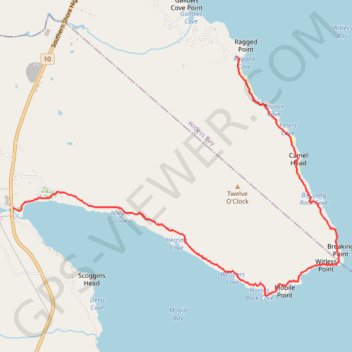
  • Distance: 6.8 Km
  • Elevation gain: 136 m
  • Maximum elevation: 38 m
  • Elevation loss: 138 m
  • Minimum elevation: 0 m

Interactive trail map

Trail profile

  • Distance: 6.8 Km
  • Elevation gain: 136 m
  • Maximum elevation: 38 m
  • Elevation loss: 138 m
  • Minimum elevation: 0 m

About this trail

Name: East Coast Trail - Beaches Path trail, distance, elevation, map, profile, GPS track

Start: Gallow's Cove Road, Witless Bay, Newfoundland, Newfoundland and Labrador, A0A 4K0, Canada (47.26268 -52.81193)

End: Beaches Path, Newfoundland, Newfoundland and Labrador, Canada (47.24890 -52.84182)

Coordinates: 47.24088 -52.84182 47.26268 -52.79813

Gear up for your next adventure:

👄SPF Lip Balm - Prevent sun and wind-burnt lips on mountain ridges
🎒Dry Bags - Waterproof bags for outdoor gear
🖼️Scratch-off Australia Map - Track the regions and peaks you have explored geographically
🎒Tactical Waist Packs - Quick access to your compass, phone, and snacks while walking
🛌Sleeping Mats - Insulated mats for camping comfort

As an Amazon Associate, this site earns from qualifying purchases at no extra cost to you.