Trail de l’Étendard - 44km
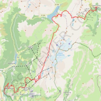
- Distance: 45.0 Km
- Elevation gain: 3,160 m
- Maximum elevation: 2,726 m
- Elevation loss: 2,362 m
- Minimum elevation: 723 m
Interactive trail map
Trail profile
About this trail
Name: Trail de l’Étendard - 44km trail, distance, elevation, map, profile, GPS track
Coordinates: 45.08189 6.01947 45.22096 6.22961
Other hiking, mountain biking, running and outdoor activity trails
Click on a trail to view its statistics, map and profile.
Rando découverte : refuge de l'étendard, glacier de Saint Sorlin et recherche d'une brèche dans les massifs rocheux afin de pouvoir y aller depuis l'alpe d'Huez lors d'une prochaine expédition. Retour à la voiture juste avant la tombée de nuit après s'êt
France > Auvergne-Rhône-Alpes > Savoy > Saint-Sorlin-d'Arves
Distance: 26.2 Km • Elevation gain: 1,366 m • Maximum elevation: 2,738 m
Chemin de Saint-Jacques-de-Compostelle
Switzerland > Geneva > Geneva
Distance: 1,117.8 Km • Elevation gain: 25,262 m • Maximum elevation: 1,430 m
PT23DS2 Lörrach → Cadaqués
Germany > Baden-Württemberg > Landkreis Lörrach > Lörrach (Kernstadt)
Distance: 1,050.7 Km • Elevation gain: 13,130 m • Maximum elevation: 1,505 m
Pointe du Sifflet depuis Prabert (Belledonne)
France > Auvergne-Rhône-Alpes > Isère > Laval-en-Belledonne > Prabert
Distance: 17.4 Km • Elevation gain: 1,292 m • Maximum elevation: 2,290 m
ACTIVE LOG
France > Auvergne-Rhône-Alpes > Isère > Allemond
Distance: 7.3 Km • Elevation gain: 970 m • Maximum elevation: 2,196 m