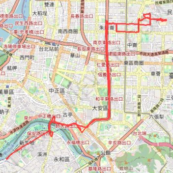
17-Feb-2025-0822小朋友上學
- Distance: 23.1 Km
- Elevation gain: 188 m
- Maximum elevation: 26 m
- Elevation loss: 186 m
- Minimum elevation: 0 m
Interactive trail map
Trail profile
About this trail
Name: 17-Feb-2025-0822小朋友上學 trail, distance, elevation, map, profile, GPS track
Start: 綠光河岸停車場, 機車道, Heti Village, Yonghe District, 溪洲, New Taipei, 23442, Taiwan (25.01821 121.51643)
Coordinates: 25.00910 121.49950 25.05805 121.55902